


Rediscover the Bolivar Wells
Locate uncharted fish attracting shell pads by combining modern day tools and technology.
Story and photography by Nate Skinner
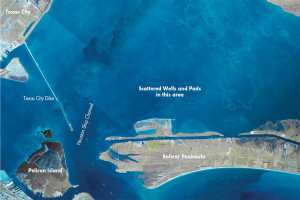
In the 1970s and 80s some of the hottest speckled trout fishing spots in Galveston Bay were the scattered wellheads and their shell pad bases below located off the Bolivar Peninsula. The shell pads were the actual attractant for trout as they rose off of an otherwise featureless bay floor creating structure for fish to relate.
Finding these highly visible fish magnets was just a matter of opening your eyes and looking for the “Christmas trees†surrounded by their protective steel barriers. Then using old fashion sounders, paper graph recorders or just trial and error anglers would probe the edges and corners of the shell bases looking for their quarry.
GLS Map of Oil/Gas Platforms & Pads
Instructions:
Click on link. Agree to terms. Click the box “Energy Resources”, then zoom in until the portion of the Texas bay or offshore is show. The well locations are noted and GPS coordinates can be obtained from the lower left hand corner of the page.
This link also locates well locations in other areas in the Texas Bay, on and off shore.